
Subscribe!
The (almost) Bike Lane That Brought Cranston Together
The city’s often-sparring factions found their common ground and worked together – with positive results.
Photos and plans presented at City Hall showed a strip through the center of private landscaped property to be taken by eminent domain for a bike lane.
A call from a concerned resident to Cranston City Council President Daniel Wall set in motion the opposition that led the Rhode Island Department of Transportation (RIDOT) to remove a proposed bicycle route from its plans embedded into a federally funded Route 37 project.
Wall was the city official who first investigated the resident’s concerns and led the pushback. No one was aware of the proposed bike lane plan – not the residents, not the Council, and not Mayor Hopkins. While bike lanes for Cranston had been mentioned years ago, opposition of the administration had been expressed and the project considered off the table – until a few weeks ago.
During an August 5 Public Works Committee meeting, Wall displayed a photograph showing a section through the center of a privately maintained landscaped property that RIDOT intended to acquire by eminent domain for the shared-use path.
Watch the Bike Path discussion – from 36:38 to 46:40
What RIDOT proposed
The proposal involved more than conventional painted bicycle lanes.
RIDOT planned a separate shared-use path beginning near Chapel View along the west side of New London Avenue, also designated Route 2. It would have continued along the south side of Meshanticut Valley Parkway and ended at Belvedere Drive.
From there, an on-street advisory bicycle lane would have continued along Belvedere Drive, Freehold Avenue, Oaklawn Avenue and Sherman Avenue before reaching the existing Washington Secondary Bike Path.
The Washington Secondary, sometimes called the Cranston or West Bay Bike Path, runs approximately 19 miles from Cranston into western Coventry along a former railroad corridor, according to RIDOT. The connection would then join east and west paths.
The Route 37 proposal included sidewalk widening along Meshanticut Valley Parkway and signalized crossings along the route. Much of the controversy focused on the Meshanticut Valley Parkway portion, where the path would not simply have followed an existing sidewalk at the outer edge of the roadway.
After a resident contacted him, Wall investigated the route and obtained information showing where RIDOT intended to build it.
During the council meeting, Wall displayed a photograph of one affected property. The proposed path would have taken a strip through the center of a landscaped yard. Wall explained that RIDOT intended to obtain the necessary property through eminent domain.
The photograph showed mature trees and established landscaping in the proposed construction area. Wall said that even if the trees were not cut down directly, excavating through their root systems could kill them.
“This would go right through the center of this landscaping,” Wall said. He argued that government should not take private property without first considering the effect on residents, their homes, landscaping and property values – and certainly not without informing them..
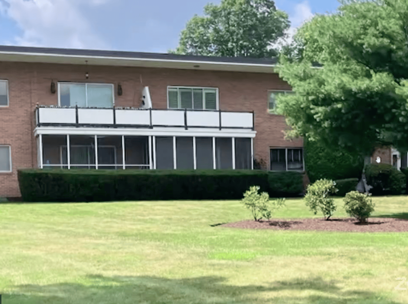
Council President Daniel Wall’s presentation includes the property photograph and explanation of the proposed eminent-domain taking.
“The way they executed this plan was out of line, inappropriate,” Wall said. In a WJAR report he also said that the chances of a future bicycle route through that neighborhood were “zero.”
RIDOT removes the bike path from their federal agreement plan
In an August 3 letter to Hopkins, interim RIDOT Director Robert Rocchio said the department had decided to remove the shared-use path segments following discussions with the Hopkins administration and concerns raised by City Council members and residents.
The letter identified the route as New London Avenue and Meshanticut Valley Parkway, continuing onto Belvedere Drive toward the existing Cranston Bike Path. Rocchio said RIDOT would contact the city and conduct public outreach before proposing future bicycle facilities along city roads.
In response to questions from RINewsToday, RIDOT confirmed that the bicycle facilities were included in its federally funded Route 37 Bridge Group 51C project.
“RIDOT has been in conversation with FHWA, which is in agreement with RIDOT’s decision to remove the bike facilities from this project while it evaluates alternatives and engages in a public outreach process before including them in a future project,” Acting Chief of Communications Charles St. Martin said.
Bridge Group 51C will repair or replace six bridges and remove two obsolete bridges. RIDOT places the total projected cost of that phase at approximately $142.8 million, with construction scheduled to continue through 2028..
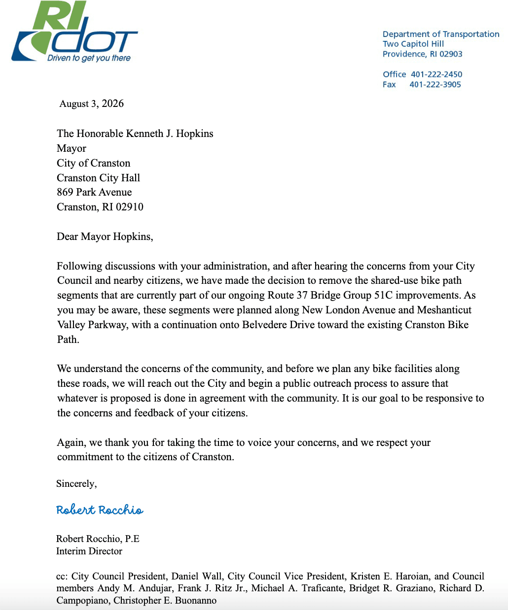
August 3, 2026 letter from interim RIDOT Director Robert Rocchio to Cranston Mayor Kenneth Hopkins.
Mayor Hopkins: “Not in Cranston”
In an August 6 interview with Gene Valicenti, Mayor Hopkins said he contacted Cranston Chief of Staff Anthony Moretti and interim RIDOT Director Rocchio after learning where the route would go. Hopkins made clear that he opposed bringing it through the affected neighborhoods.
He cited the potential taking of private property and safety concerns, including the route’s proximity to Glen Hills Elementary School. Hopkins also said red survey or construction flags had appeared along portions of the proposed corridor.
Hopkins stressed that he is not opposed to bicycle paths generally and pointed to the popularity of Cranston’s existing rail-trail. His objection, he said, was to this particular route, its effect on private property and the way RIDOT advanced it without adequate public outreach.
Hopkins has since summarized the city’s response with the slogan “NIC — Not in Cranston.” Very reminiscent of the time years ago when Cranston stopped out-of-control mini-bikes and ATVs from careening from Providence to Cranston. Years before that another administration stopped BLM rioters causing damage in downtown Providence from their stated intent of damage to Garden City Center.
Cranston is the state’s 2nd largest city.
Cranston Mayor Kenneth Hopkins discusses the RIDOT bicycle proposal with Gene Valicenti on August 6, 2026. Audio: WPRO/“The News with Gene Valicenti.”
The route had been in government documents for years
Although the proposal became a matter of broad public controversy this summer, it was not a new addition to the Route 37 project. A detailed version appeared in RIDOT’s February 2023 application for a federal RAISE grant.
The application described a shared-use path along the west side of Route 2, beginning near Chapel View and proceeding along Meshanticut Valley Parkway. It also contemplated a connection through lower-volume Cranston streets to the Washington Secondary Bike Path.
RIDOT received a $25 million federal RAISE grant for the Route 37 project in June 2023. The application said RIDOT had worked with local stakeholders and referred to coordination with the City of Cranston. However, the support letters posted with the federal application include Warwick officials and organizations but do not appear to include a Cranston letter of support.
A second detailed route description appeared in an April 9, 2026 RIDOT letter addressed to Wall. The stated purpose of that letter was to request a city permit allowing construction within 25 feet of State Farm Cemetery No. 1, a historic cemetery buried beneath Route 37. The bicycle route appeared on the second page of the four-page cemetery-permit package.
The request was placed on the June 9 Public Works Committee agenda and carried over to August 5. The public record does not explain why the bicycle component was not presented as a separate neighborhood project. The April letter also described RIDOT as preparing the project “in cooperation with your municipality.”
Those records show that route details existed in government paperwork. They do not demonstrate that RIDOT held a neighborhood meeting, mailed notices to affected property owners or clearly presented the property-taking component before survey markings appeared.
Technical notice contained inside a cemetery-permit application is not the same as meaningful public outreach to residents whose property is to be taken.
Earlier RIDOT documents described a much smaller property impact
The private-property taking shown during Wall’s presentation also appears inconsistent with RIDOT’s earlier description of the project. The 2023 federal grant application included $300,000 for “right-of-way easements/acquisitions” as part of the overall Route 37 project. The original schedule called for those acquisitions and easements to occur between September and December 2024. That allocation applied to the larger Route 37 project and was not identified exclusively as funding for bicycle-path property acquisitions.
Elsewhere, however, the same application said all required right-of-way was already state-owned or being used for transportation purposes, with only “a small easement” potentially needed for the shared-use path along Route 2.
The final route documented by Wall involved considerably more than the small Route 2 easement described in the federal application. It included taking a section through the center of privately maintained residential property along the Meshanticut Valley Parkway portion of the route.
RIDOT has not publicly explained when the design expanded onto that private property, how many properties were affected, how much land it intended to acquire or whether owners had received appraisals, purchase offers or formal condemnation notices.
The earlier federal documents and the later property plan therefore describe materially different effects.
That discrepancy strengthens the central question surrounding the project: How did a route requiring the taking of private residential property reach this stage without direct notice to the owners or a public presentation to Cranston officials?
Cranston has supported a different east-west path
Cranston’s planning history shows that the city has supported the concept of an east-west bicycle and walking route—but along a substantially different corridor. The city’s 2010 Comprehensive Plan recommended investigating a dedicated east-west path using a Providence Water Supply Board aquifer right-of-way.
In 2012, the City Council approved a resolution sponsored by then-Councilman Steve Stycos calling for a bicycle or walking trail along the Water Supply Board easement from Pontiac Avenue toward Midway Road and beyond.
A conceptual map placed that route approximately parallel to Sockanosset Cross Road and behind the Garden City area. The city’s 2024 Comprehensive Plan continues to recommend consideration of the Water Supply Board corridor.
The much increased development of both Garden City Center and Chapel View, including the Top Golf development and its impact on traffic and safety may need to be considered before any bike path in that area is considered again.
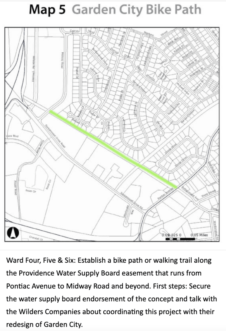
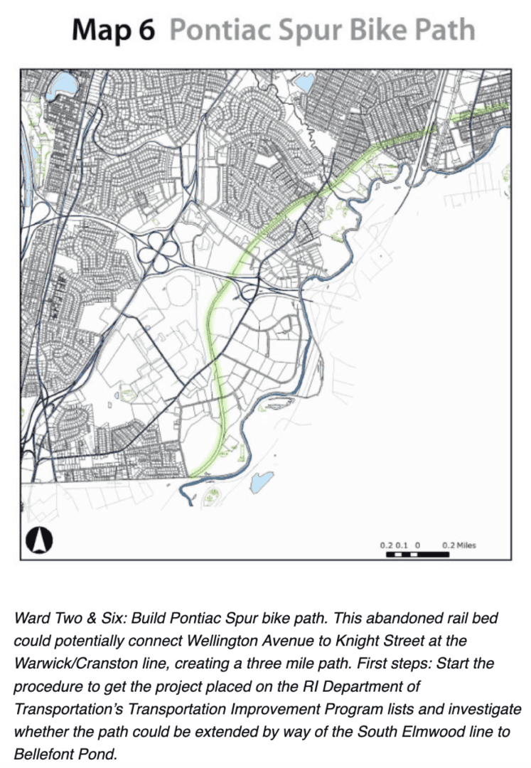
A 2012 Cranston Parks Plan map shows a proposed bicycle and walking trail along the Providence Water Supply Board easement from Pontiac Avenue toward Midway Road and beyond. The concept is separate from RIDOT’s Route 37 proposal. Source: Cranston Parks Plan/West Bay Land Trust.
Rhode Island’s history of bicycle-lane controversy
Cranston’s immediate reaction also followed several highly publicized bicycle-lane disputes in Providence.
In 2019, a two-way bicycle lane on Eaton Street near Providence College was removed only weeks after being installed. Residents said the redesigned roadway was too narrow for vehicles and emergency equipment, and their driveway access. Installation cost approximately $63,500. Removal, redesign and restoration of the original traffic pattern cost another $64,000—a total of $127,500, according to media reports.
South Water Street in Providence became another battleground after Providence converted one of two vehicle lanes into a protected, two-way bicycle path in 2021. Businesses, Brown University and others raised concerns about congestion, deliveries and large trucks extending into the remaining travel lane.
Providence’s current plan retains the bicycle connection but moves it to a separated, sidewalk-level urban trail while restoring the second vehicle lane and enlarging the parking lane. The city has described the change as correcting flaws in the original design. The replacement is part of a $4.4 million federally funded project.
Hope Street on Providence’s East Side produced perhaps the most divisive debate. An eight-day temporary trail was installed between Olney and Lauriston streets in October 2022, including the narrow commercial district. The demonstration temporarily displaced 132 parking spaces on one side of Hope Street. Supporters said it demonstrated how a protected trail could make cycling safer. Merchants and residents questioned the effect on parking and small businesses, the street’s narrow dimensions and the credibility of the outreach and data.
RINewsToday extensively covered the dispute and documented the concerns of merchants and residents. The temporary trail was removed after the demonstration. A permanent Hope Street trail did not follow.
The three projects produced different outcomes: Eaton Street was installed and quickly reversed; South Water Street is being substantially redesigned; and Hope Street received a temporary trial but not a permanent installation.
Together, they created a difficult public-relations environment for subsequent bicycle proposals.
“Bike lane” no longer necessarily means just bicycles
Cranston residents also raised questions about whether electric bicycles, scooters or other motorized devices would be permitted on the proposed shared-use path. That concern is being debated nationally.
As The New York Times reported, New York City lawmakers are considering a broad package of regulations following serious and fatal crashes involving electric bicycles and scooters. The New York City Council says more than 500 e-bike collisions have occurred there in 2026 and that such collisions are up 31.7 percent from last year.
Proposals include prohibiting the sale or rental of Class 3 e-bikes, licensing delivery companies, requiring delivery platforms to verify moped registrations, considering additional insurance requirements and increasing enforcement against illegal high-speed devices.
In Rhode Island, state law specifically permits Class 1 pedal-assist e-bikes, which stop providing assistance at 20 mph, on state bicycle trails and paths. The law does not grant the same statewide path access to throttle-operated Class 2 e-bikes, faster Class 3 e-bikes or ordinary electric scooters.
Safety arguments take serious tone
Poor siting and inadequate outreach can generate lasting opposition. A recent Chicago death illustrates the competing danger of providing bicycle lanes without adequate physical protection. On June 5, Riley O’Neil, a 35-year-old planner with the Chicago Department of Transportation’s Complete Streets program, was riding in a paint-only bicycle lane on Halsted Street when the driver of a parked vehicle opened a door into his path.
O’Neil struck the door and was thrown into the adjoining traffic lane, where he was struck and killed by a semitrailer. Police cited the driver for improperly opening the door, prohibited parking, driving with a suspended license and operating an uninsured vehicle, according to the Chicago Sun-Times. O’Neil had devoted his career to making Chicago’s streets safer for bicyclists and pedestrians. His death prompted renewed demands for bicycle facilities physically separated from parked and moving vehicles.
Louisa Gag, a 36-year-old Boston transportation planner and longtime safe-streets advocate, was struck and killed by a truck on July 9, 2026, while bicycling to work on Tremont Street near Roxbury Crossing in Boston. Her death sparked widespread mourning, a large vigil at Boston City Hall, and renewed pressure on city leadership regarding bike infrastructure timelines. Gag spent her career working on Vision Zero initiatives and advocating for safer cycling and pedestrian infrastructure, including previous roles with the Livable Streets Alliance and the City of Boston.
The Chicago and Boston examples lead to the same conclusion: the words “bike lane” reveal little about whether a particular proposal is safe or appropriate. The route, width, physical separation, surrounding traffic, parking, emergency access, affected property, permitted devices, enforcement and public process all matter.
The idea of “retrofitting” a traffic lane made for cars, trucks and buses to accommodate bike and ebikes, simply can’t be done with paint and bollards – and proclaimed safe.
What is settled—and what remains unanswered
The bicycle facilities are now out of the current Route 37 Bridge Group 51C project, and the Federal Highway Administration agrees with RIDOT’s decision. RIDOT says it will evaluate alternatives and conduct public outreach before including bicycle facilities in a future project.
The inclusion of “safe streets” or “traffic calming” projects in large multi-million infrastructure grants has been practiced for several years, particularly in the Biden administration. That interest led to federal grants for coordinator positions in certain larger cities, such as Providence and Boston. In 2025, the Trump administration removed bike lane requirements from the “have-tos” of federal construction plans and removed federal funding of them in the future.
___
How Safe Are Bikers?
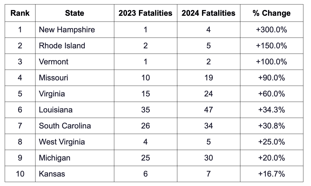
Rhode Island recorded 5 bicycle fatalities in 2024, up from 2 in 2023, a 150% increase, the second-largest percentage rise of any state in the nation, while the national total fell 6.3% from 1,207 to 1,131 deaths, according to an analysis of FHWA CDAN crash data conducted by High Rise Financial.
___
Editor’s Note: What began with one resident contacting a Councilman and then a Mayor’s involvement, ended up in a somewhat rare opportunity for Cranston to learn that it can work together for the greater good of the city. We hope to see more of it.
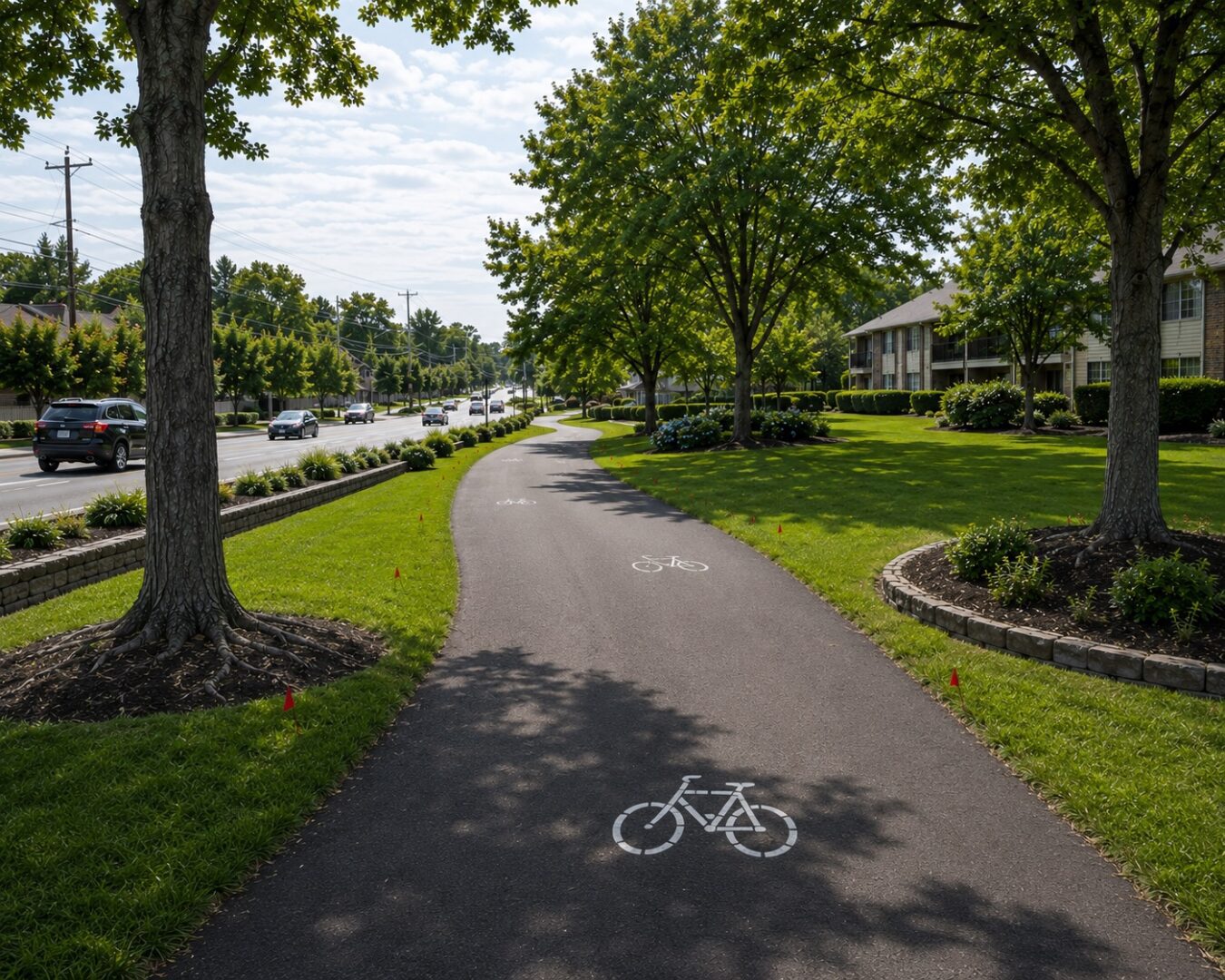
Photo, top, AI assisted
The other thing this article points out is how getting Federal Money always has strings attached to it.
Tahe a look at the bike lanes on Willard Ave in Riverside They have caused near misses of cars turning in shopping plazas the bike lanes go NOWHERE.
Yes, familiar with that location – hopefully they will be removed from dangerous, inappropriate spots like that
Nice article.