UPDATES will be ongoing – in red, HERE, throughout the storm:
MONDAY UPDATES:
The snowstorm has slowed and will be hitting us more in the daylight hours today. Most powerful winds and snow expected to end by evening. Prepare for power outages. Winds have picked up in the southern part of the state. This is heart attack-shoveling snow – be cautious – arrange now for plowing if you have not done so already. THIS IS WHERE WE WILL UPDATE information – check back often.
Power outages as of early morning publication time:Â

SNOW REMOVAL:Â This is not the kind of snow you want to consider shoveling yourself if you have a health condition such as high blood pressure or heart disease, or you are out of shape or over the age of 50. If you MUST shovel, Matt Espeut, owner of Providence Fit Body Boot Camp has back-saving tips:
___
Updates from Sunday:
UPDATE #1 – Snow totals increased to as much as 28 inches (Blizzard of 78 was 30″ in Prov, 20 ft. snow drifts). 50-70 mph wind gusts expected. Snow wet and heavy, difficult and dangerous to shovel. Prepare for sustained power outages. Schools to close for 2-3 days. Some flights out for today already rescheduled to – Thursday.
UPDATE #2 – 11am – After this snowstorm: National Weather Service predicts for RI:
Tuesday – high 31 – no precip. Wednesday – 70% chance of rain & snow before 2pm, then a chance of rain. Thursday – Rain > 1pm, then rain & snow, then back to rain. Friday – Chance of rain & snow. Saturday – Mostly sunny, with a high near 42.
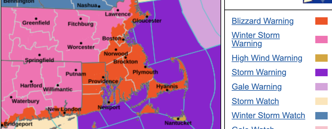
UPDATE #3 – noon – Nearly 54 million people in the path of this storm reside within a Winter Storm or Blizzard Warning from the Central Appalachians to Coastal Maine.
UPDATE #4 – 1:45pm – Governor’s update:
| Governor Dan McKee today declared a State of Emergency for Rhode Island, issued a travel ban, and enabled the activation of the Rhode Island National Guard as needed ahead of blizzard conditions that will impact the entire state beginning on Sunday evening. The Governor is also activating the State Emergency Operations Center for the duration of the storm.
“We’re asking Rhode Islanders to take this storm seriously and stay home,â€Â Governor McKee said. “This is an all-hands-on-deck response. Our state agencies have the resources and manpower they need to respond and keep Rhode Islanders safe.†|
|
| Forecast
The National Weather Service has issued a blizzard warning for Rhode Island beginning on Sunday, February 22, at 4:00 p.m. through Tuesday, February 24, at 7:00 a.m. The current forecast shows the potential for 18 to 24 inches of heavy, wet snow with wind gusts up to 60 mph across the state. The heaviest accumulation, along with whiteout conditions are expected between 1:00 a.m. and noon on Monday. Blizzard conditions are expected to create hazardous travel, with severely reduced visibility and the potential for power outages. |
|
| Travel Bans
Beginning on Sunday, February 22, 2026, at 5 p.m., there will be a restriction on commercial vehicle travel on all roads statewide. Beginning on Sunday, February 22, 2026, at 7 p.m., there will be a restriction on all motor vehicle travel on all roads statewide. These restrictions will be in effect until further notice. Vehicles transporting emergency supplies and/or emergency personnel will be exempt from these restrictions.
The order can be viewed here. |
|
| State Government Operations
State government offices will be closed on Monday from 8:30 a.m. to 4:30 p.m. During the State of Emergency, all non-essential state personnel are relieved from duty. Essential personnel, as determined by their respective agencies, should report to work and/or remain at work.
The Rhode Island Department of Transportation (RIDOT) has approximately 500 state and vendor plows and 60,000 tons of salt available. Roads have been thoroughly pretreated, and crews will be reporting well in advance of the storm. |
| The Executive Office of Housing announced the activation of all emergency pop-up sites to help Rhode Islanders in need remain safe and warm during the storm. The following emergency pop-up sites operated by the R.I. Council of Churches will be open from 5:00 p.m. tonight to 7:00 a.m. Tuesday, February 24. To access a site listed below, individuals should first go to Matthewson Street Church. |
- Matthewson Street Church – 134 Matthewson St., Providence Â
- Community Church of Providence – 372 Wayland Ave., Providence Â
- Open Table of Christ – 1520 Broad St., Providence
|
|
| A fourth emergency pop-up site, operated by the Town of West Warwick, will be open from 5:00 p.m. tonight to 9:00 a.m. Tuesday, February 24. To access this site, individuals can go directly to the address below. |
- West Warwick Civic Center – 100 Factory St., West Warwick
|
|
| Rhode Island Emergency Management Agency (RIEMA) is monitoring storm activities throughout the weekend and will remain in close communication with local emergency management departments to ensure communities have the necessary support in place. Find a list of local warming centers here.
RIEMA is also working with the Rhode Island Red Cross to stand up the following regional shelters for additional capacity:
- Gaudet Middle School — 1113 Aquidneck Ave, Middletown (4 p.m.)
- Jenks Middle School — 350 Division St, Pawtucket (6 p.m.)
The following shelters are on standby:
- Cumberland High School — 2600 Mendon Rd, Cumberland, RI
- Broad Rock Middle School — 351 Broad Rock Rd, Wakefield, RI
|
| The Office of Energy Resources is in close contact with Rhode Island Energy, Clear River Electric & Water District, Block Island Utility District, and the state’s delivered fuel terminals to monitor the storm’s impact on power and fuel supplies across the state.
Rhode Island State Police has called in extra troopers who will be monitoring the highways and assisting motorists as needed.
The Governor’s State of Emergency enables the activation of the Rhode Island National Guard (RING) to support the statewide response. RING has guard members on standby, ready to assist throughout the storm as needed. |
|
| With high winds expected to cause power outages, Rhode Island Energy has secured additional crews to support restoration efforts, which are anticipated to extend into multiple days. At this time, 200 line crews and 80 forestry crews are ready to respond. The company’s storm operations center will be activated Sunday night, and staging sites have been established at CCRI Warwick, Ninigret Park, and Middletown. Rhode Island Energy will continue to closely monitor conditions and evaluate resources as needed throughout the storm. |
|
RIPTA Update – RIPTA to Suspend All Service, Including RIde Paratransit, Beginning at 9pm tonight, Sunday, February 22, 2026, through Monday, February 23, 2026 – Service will be reinstated as soon as conditions allow.
_______
The National Weather Service has issued a Blizzard Warning for the entire State of Rhode Island commencing at 2-4pm Sunday, today. In addition to classic nor’easter traits, this storm will also go through bombogenesis, where the central pressure of a storm drops 24 millibars in 24 hours – taking on the characteristics of a bomb cyclone and a nor’easter, together.
In addition widespread power outages will be possible from the winds, which could violently gust as high as 70 mph.
Totals increased from as much as 20″ – to as much as 24″.
In the Blizzard of ’78 snow buried Rhode Island under roughly 27–30 inches of snow, with hurricane-force winds of 70-80mph, creating massive drifts reaching 10–15 feet in some areas, and shutting the state down for days. The big difference between ’78 and 2026 is that we KNOW what is coming, we will NOT be on the roads, and we WILL prepare!
In most cases of storms coming up the coast, it is the coastal states – like Rhode Island, and southern RI – that will receive less or a mix with rain – IN THIS CASE it is the opposite, with coastal areas getting hit more than inland areas.
What we know:
___
â„ï¸Â Operation Winter Weather Warning â„ï¸
PREPARE NOW
Strong winds & heavy wet snow may cause power outages
Dangerous conditions – some forecasts call for as much as 20-24″ in RI area
|
|
Rhode Islanders are urged to prepare today ahead of a powerful coastal storm expected to impact southern New England late Sunday into Monday. Named Hernando, this storm will be a Blizzard, with strong winds & heavy wet snow which may cause power outages. This will cause dangerous conditions – some forecasts call for as much as 20″ in RI area.
Power outages may be the biggest threat
The most disruptive impact may be the loss of electricity.
Heavy wet snow combined with wind gusts of 40–80 mph can:
- snap weakened tree limbs
- bring down power lines
- uproot trees in saturated ground
- delay restoration due to blocked roads
Neighborhoods with dense tree cover and older utility corridors may be especially vulnerable.
Report outages & get updates
Contact for Rhode Island Energy – 📞 855-743-1102 – 🌠rienergy.com/outages
Stay at least 30 feet away from downed wires — call 911
Restoration priorities: public safety hazards, hospitals, major circuits – then neighborhoods.
Significant snowfall could worsen existing conditions
Additional heavy snow may compound already difficult conditions across Rhode Island:
- narrowed streets and limited parking
- clogged sidewalks forcing pedestrians into roadways
- reduced emergency vehicle access
- sanitation and trash collection challenges
During recent severe weather periods, Rhode Island has experienced tragic deaths among people exposed to extreme cold. Dangerous conditions increase risk for:
- individuals experiencing homelessness
- elderly residents and those without reliable heat
- pedestrians navigating blocked sidewalks
- residents forced to park farther from home
Timing (current outlook)
Sunday: rain or wintry mix develops during the day and early evening, little accumulation
Sunday night, late as midnight, into the day on Monday: heaviest snow & strongest winds
Monday: Continued heavy snow. Late, hazardous travel and cleanup challenges likely
No School Day(s) most likely for Monday, possible Tuesday and Wednesday delays
WHAT TO DO NOW
Take these steps today before conditions deteriorate:
✔ Charge phones, power banks & medical devices
✔ Locate flashlights & replace batteries (candles, if necessary)
✔ Fuel vehicles & safely position generators, outdoors
✔ Purchase medications & essential supplies, water
✔ Set refrigerators/freezers to colder settings
✔ Move vehicles to allow plow access if possible – parking bans will be strictly enforced
✔ Clear vents & hydrants safely
✔ Check on family, elderly & vulnerable residents to let them know impending conditions
✔ Contact your snow removal person(s) and put that plan in place
✔ Take a snow shovel and snow brush inside – last snowstorm we know people who could not get their doors open – as it snows, make sure your means of exit is cleared enough to open your door
Prepare for possible outages
- Identify a backup place to stay if heat is lost
- Have blankets and extra layers ready
- Take out secondary light sources, to have at the ready
- Keep water and nonperishable food accessible
- Unlock cars to ease access if you need to warm up or charge phones
- Unplug sensitive electronics before outages
Food remains safe about 4 hours in a refrigerator and 24–48 hours in a full freezer.
Stay informed — and prepare!
Forecast details may continue to change, but this storm has the potential to bring significant snowfall, strong winds, and dangerous conditions. Prepare now. Prevent emergencies later. |
|
___
City of Providence
Citywide parking ban will go into effect at 3PM on Sunday, February 22 until further notice.
The parking ban will prohibit parking on all snow routes and city streets to allow snowplows to clear roadways effectively. The ban will remain in effect until further notice, and violators may be subject to ticketing and towing. During a parking ban, residents, including those with an overnight parking permit, are not allowed to park on city streets. Parking in Providence Public School parking lots is prohibited during a parking ban.Â
Overnight permit holders will now be able to park at one of sixteen approved locations citywide. If there is not an approved location nearby, residents can use another approved site, including on-street locations adjacent to city parks, parking lots within city parks and select on-street locations on particularly wide streets.  Â
Permit holders can move their vehicle to an approved location once a snow parking ban is announced. After the ban is lifted, residents have eight hours to move their vehicle from the approved location. Vehicles left past this grace period may be ticketed or towed to allow city plows to clear streets efficiently.  Â
Beginning Sunday, February 22 at 3PM through the time the parking ban in Providence is lifted, discounted parking will be available at the following locations:
- Rhode Island Convention Center North Garage
99 West Exchange Street, Providence
- Innovation District Garage (IDG)
75 Clifford Street, Providence
To support residents who may need a safe and convenient parking option during the storm, overnight parking will be available for a flat rate of $10 (tax not included),
To facilitate snow removal and ensure safety, all micromobility services, including shared bikes and scooters, will be temporarily paused starting at 4PM on Sunday, February 22 and will remain paused until the City’s snow parking ban is lifted.  Â
For a full list of warming centers, visit www.providenceri.gov/pema/providence-warming-centers/.  Â
___
City of Pawtucket
The City of Pawtucket has issued a CITYWIDE PARKING BAN beginning at 5:00 pm TODAY February 22nd, until further notice.
Street parking will not be permitted during this ban. For more information, including alternative parking options, visit www.pawtucketri.gov.
___
JOHNSTON, RI –
The Johnston Senior Center will open as a warming center starting at 11 p.m. on Sunday, February 22 for residents who lose power.
Airport
Airlines have proactively cancelled the majority of arrivals scheduled after 6:30 p.m. Sunday evening, as well as many departures and arrivals on Monday. These cancellation decisions are made by the individual airlines based on regional weather conditions as well as system wide operational considerations.
Rhode Island T. F. Green International Airport remains operational. Airport crews are actively preparing airfield and terminal facilities for winter weather and will continue to monitor conditions closely.
Travelers are strongly encouraged to check directly with their airline for the latest flight status before coming to the airport. Visit https://flyri.com/passengers/flight-status/ for more details.
___
Governor’s Office
In a statement from Gov. McKee, he says, “With high winds expected to cause power outages, Rhode Island Energy has brought in additional crews to support power restoration. At this time, they have 200 line crews with 80 forestry crews ready to respond.
The Office of Energy Resources is in close contact with Rhode Island Energy, Clear River Electric & Water District, Block Island Utility District, and the state’s delivered fuel terminals to monitor the storm’s impact on power and fuel supplies across the state.
Rhode Island State Police has called in extra troopers who will be monitoring the highways and assisting motorists.
The Rhode Island Department of Transportation (RIDOT) has approximately 500 state and vendor plows and 60,000 tons of salt available. Roads have been thoroughly pretreated.
Shelters
All emergency pop-up sites for individuals seeking refuge from the storm will be activated. The following emergency pop-up sites operated by the R.I. Council of Churches will be open on February 22, February 23, and February 24 from 7:00 p.m. to 7:00 a.m. To access a site listed below, individuals should first go to Matthewson Street Church.
- Matthewson Street Church – 134 Matthewson St., Providence
- Community Church of Providence – 372 Wayland Ave., Providence
- Open Table of Christ – 1520 Broad St., Providence
A fourth emergency pop-up site, operated by the Town of West Warwick, will be open on February 22 from 5:00 p.m. to 9:00 a.m. To access this site, individuals can go directly to the address below.
- West Warwick Civic Center – 100 Factory St., West Warwick
These emergency pop-up sites are opening in addition to seasonal emergency shelters, overnight warming centers, daytime resource and warming centers, and year-round shelters, all available to help Rhode Islanders remain safe and warm during the storm. For a full list of resources and locations, visit https://housing.ri.gov/resources/individuals-experiencing-homelessness.
NOTE: For a full list of the City of Providence warming centers, visit www.providenceri.gov/pema/providence-warming-centers/.  Â
There will be press conference TODAY at 1:45pm.