Search Posts
Recent Posts
- Out and About in RI: Former Pawtucket Mayor Henry Kinch Tribute in Photos June 24, 2025
- Rhode Island Weather Forecast for January 24, 2025 – Jack Donnelly June 24, 2025
- ART! Mark Freedman, first featured artist of Summer Art Shows at Charlestown Gallery June 24, 2025
- The Bellevue Hotel: Procaccianti Co. New Luxury Boutique Hotel Set for Newport’s Iconic Bellevue Ave June 24, 2025
- Mike Stenhouse, CEO of RI Center for Freedom & Prosperity, named into College Baseball Hall of Fame June 24, 2025
Categories
Subscribe!
Thanks for subscribing! Please check your email for further instructions.

ART! Map of Block Island latest in hand-drawn maps by Joseph Tarella, Coastal Art Maps
The Latest in the Company’s Collection of Beautiful Hand-Drawn Maps Spotlights Block Island’s Beaches, Harbors, Lighthouses, & More
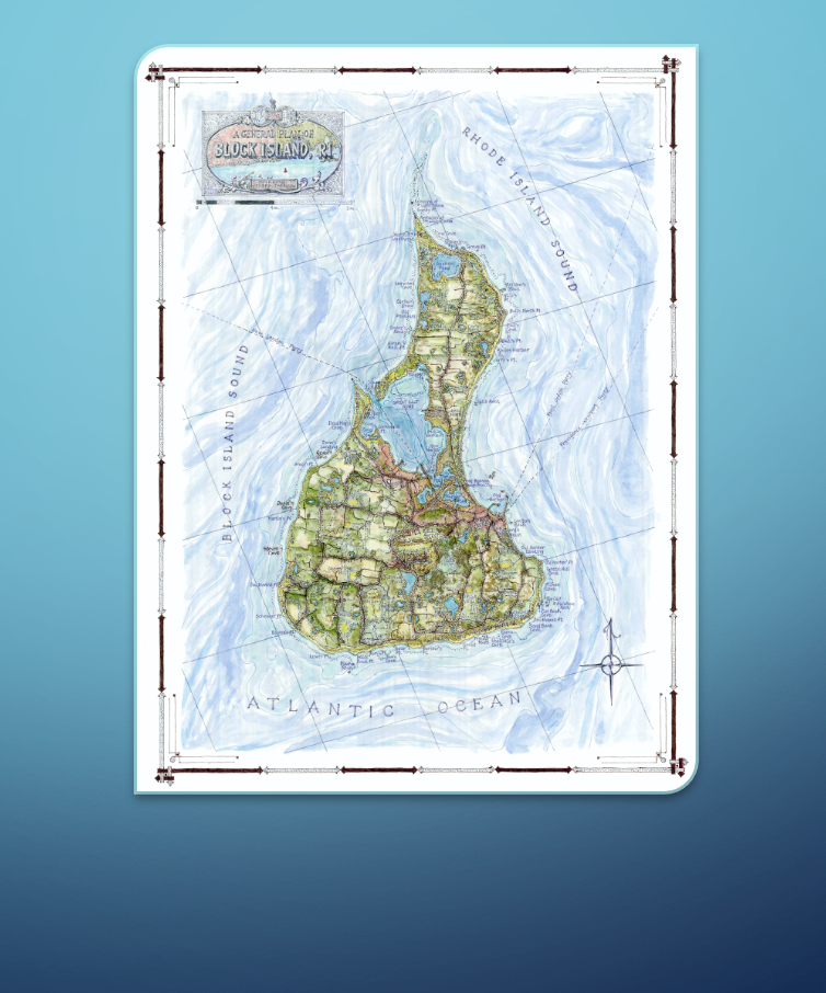
Mapmaker Joseph Tarella of Coastal Art Maps has just released his latest map spotlighting Block Island, RI, where he expertly captures the area’s diverse shoreline, beautiful beaches, outdoor trails, harbors, and more.
Mapmaker Joseph Tarella of Coastal Art Maps has just released his latest map spotlighting Block Island, RI, where he expertly captures the area’s diverse shoreline, beautiful beaches, outdoor trails, harbors, and more. Block Island, known for its natural beauty and stunning landscapes, fits nicely into the Coastal Art Maps collection, which has grown to more than three dozen different maps, spanning the New Hampshire, Massachusetts, Rhode Island, New York, New Jersey, Maryland, Delaware, South Carolina, Florida, and Texas coastlines.
Situated roughly 12 miles south of Rhode Island/Connecticut border, this quintessential Victorian island represents an idyllic vision of life the way it once was. At just under 11 square miles, a visit to this unspoiled, unhurried gem is like going back 100 years in time. Named after the Dutch navigator, Adriaen Block in the early 1600’s, it’s iconic lighthouses, magnificent harbors replete with period architecture, dramatic clay bluffs and abundant beaches, along with leafy, glacial hollows and numerous freshwater ponds, provide an amazing variety of experiences in a compact destination. Served by ferries as well as planes, it is easily reached and provides an immersive exposure to how things used to be. Once the capital of the whaling industry and still a major boating and fishing hub, the rural island prospered and remains a unique destination for visitors.
This is Tarella’s second Rhode Island map. He recently created a stunning map of the Newport area, spotlighting Newport in context with the surrounding waterways and islands (Jamestown) and highlighting the strategic positioning of the original colonial enclave. With its periodic reinvention of itself from seafaring pilgrims to prosperous whalers, then later to an upscale summer retreat (The Breakers) and yachting center (America’s Cup), this natural port has been part of the American story since the days of the Founding Fathers.
“I love Rhode Island, with its spectacular beaches, iconic lighthouses, stunning harbors, and rich history. Block Island is such a beautiful and historic area, and it was a pleasure to capture it in my latest map. The new Block Island map will be truly appreciated by anyone that has ever enjoyed time in this lovely New England area,” explained Tarella. “Each map in the Coastal Art Maps collection represents a unique moment when the ever-changing shoreline is briefly frozen in time.”
Using the time-honored tools of pen-and-ink and watercolor washes, Tarella has been able to capture a tactile quality not easily achieved using more mechanical, modern methods. Each map presents an elegant, detailed and accurate rendering of selections of coastal areas, highlighting the juxtaposition and relationships between land and water, islands, parks, roadways and other significant features of the landscape.
“My collection of maps allows me to combine my architectural experience, passion for travel and love of maps – as well as an endless fascination with the ocean – into beautiful finished products that I’ve been able to share with many like-minded people around the country,” Tarella continued. “What started out as a singular effort of creating a map of my hometown in New Jersey has transformed, over several decades, into a labor-of-love production that has allowed me to explore and represent dozens of truly interesting and beautiful locations.”
Coastal Art Maps currently offers more than three dozen shorefront maps, depicting areas in New Hampshire, Massachusetts, Rhode Island, New York, New Jersey, Delaware, Maryland, Virginia, Florida, and Texas.
These maps, reproduced on either giclee canvas or heavy-stock watercolor paper using UV-resistant inks, make satisfying and treasured keepsakes for beach or boating enthusiasts, nature and nautical lovers, sportsmen, fishermen, art collectors, history aficionados and anyone who has spent precious hours experiencing these beloved locales. They make excellent memorable gifts and enhance the décor of any home, office, boat, beach house, or other location.
Tarella is always interested in corresponding with people who want to discuss his maps. For more information, please visit www.coastalartmaps.com.
